
ird
Geomagnetic measurements are used for prospecting as well as for environmental geological questions. Locally occurring anomalies caused by magnetizable objects (minerals, iron objects,...) can be detected and delimited by means of magnetometer measurements.
The following example shows the use of proton precession magnetometers to delineate an old domestic waste dump near an old farmhouse.
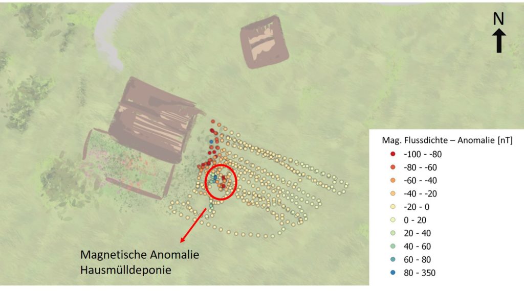
Fig. 1 Measurement result and location
Reason for the assumption of a domestic waste dump were isolated, from the earth appearing glass and ceramic shards, as well as isolated rusty iron parts. This led to the assumption that former residents (1850 -1970?) had deposited non-combustible materials there. Since the area is to be used as a garden, the removal of the affected soil is planned.
To delineate the size of the landfill in terms of area and consequently to better plan the removal, the site was surveyed with a proton magnetometer.
Geomagnetic measurements with a magnetometer are non-invasive and no boreholes or trenches need to be drilled for them. The measurement is made by walking on the site. Two proton precession magnetometers are used. A stationary measuring station measures the diurnal variation of the earth's magnetic field, while a second proton magnetometer is used to walk the area to be investigated. At measuring points, the magnetic flux density (in nanotesla; nT) is measured and the GPS coordinates of the respective point are determined. Since any magnetizable objects resonate with the magnetometer, it is important to note as much as possible any superficial, potential interfering objects as well as the course of telephone/power lines during the measurement in order to avoid misinterpretation of the data.
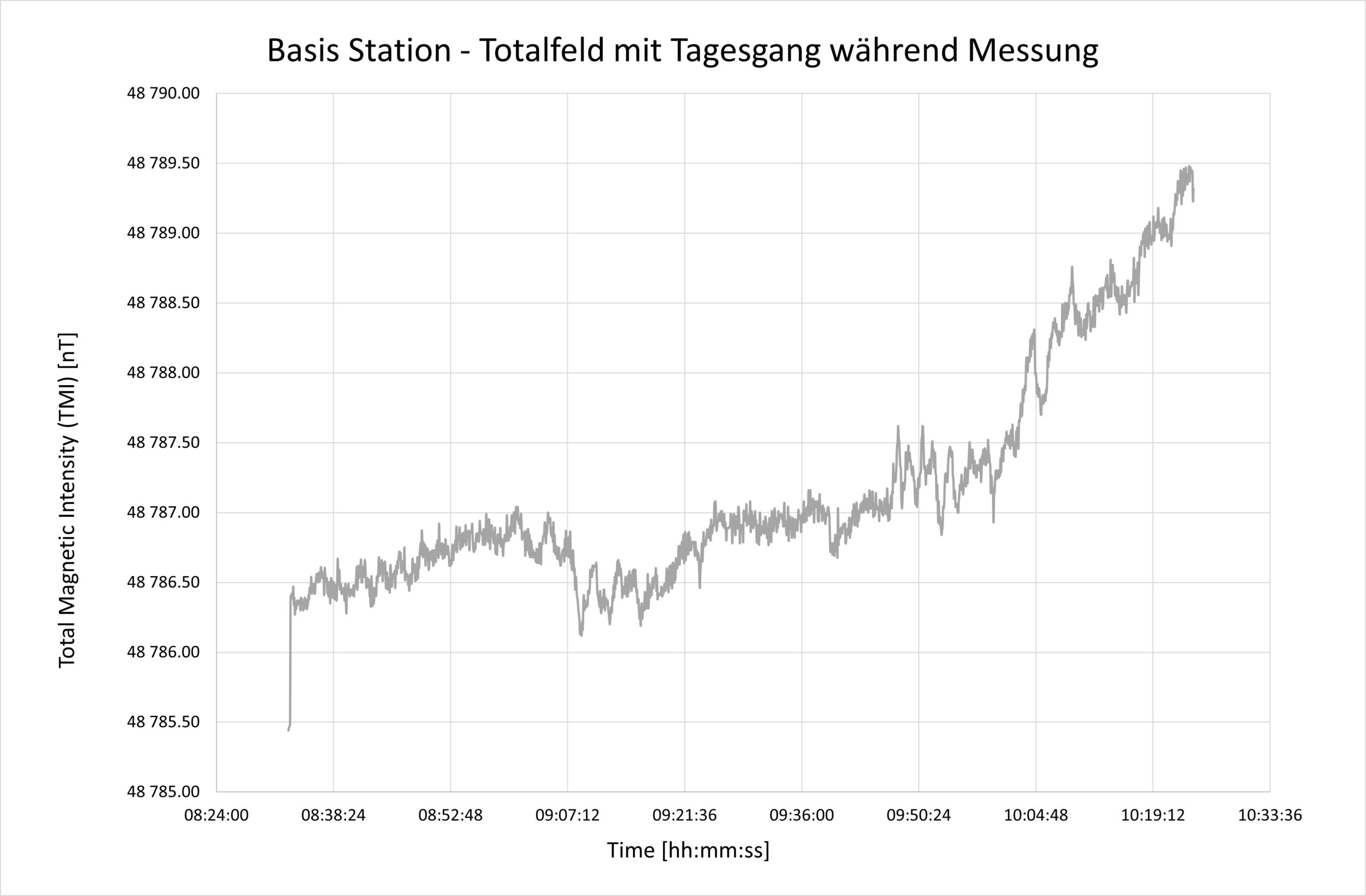
Fig. 2 Diurnal variation of the Earth's magnetic field
The data collected in the field are then combined: the diurnal magnetic variation (Fig. 2) and obvious interfering signals (cars, power boxes, fences) occurring in the measurement area are eliminated to determine the signal of the local variation. Fig. 3 shows the extracted signal (SW-NE profiles) and the clearly prominent anomaly due to the legacy in the measurement area.
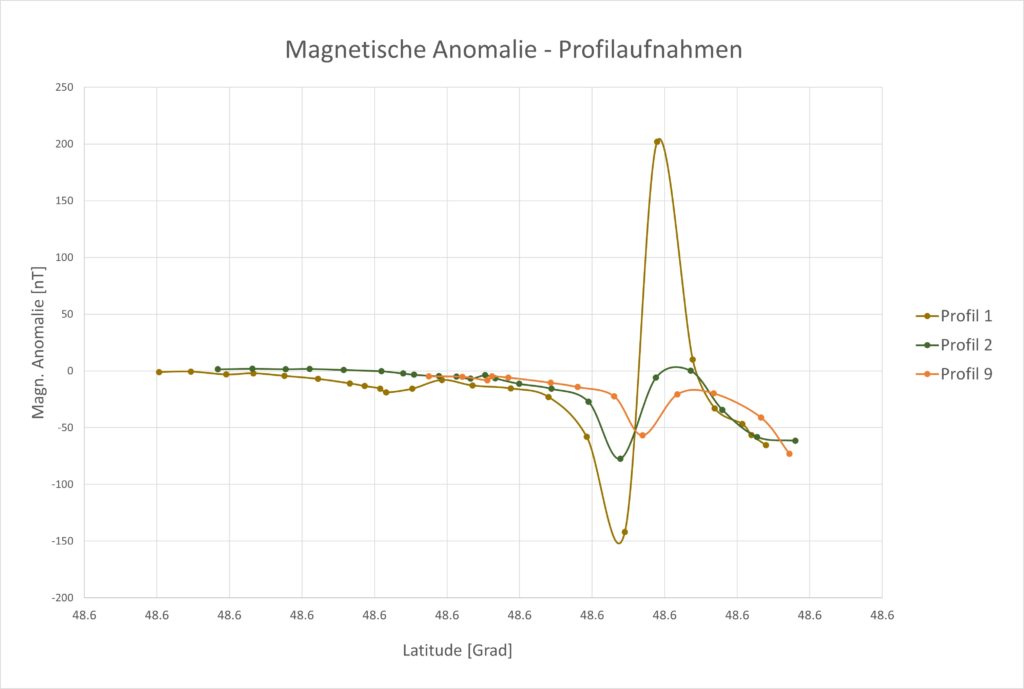
Fig. 3 SW-NE profile representations magnetic anomaly (dipole) caused by the contaminated site
The map made (cover picture, Fig. 1) allows a readable result and offer a good basis to plan further steps. The domestic waste site is characterized by a magnetic dipole with very high and low measured values. The signal strength decreases with increasing distance to the disturbing body. No other anomalies related to buried dumped material could be detected in the surrounding area.
We would like to thank the Central Institute for Meteorology and Geodynamics (ZAMG) for kindly providing the diurnal variation data to verify our measurement data.
 My name is Thomas Unterweissacher. I am a geologist and head of GEO Unterweissacher GmbH. Here we present our projects and interesting facts.